
By Max Galka
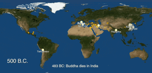
Watch the rise of human cities, beginning with [arguably] the world’s first city in 3700 BC and continuing up to the present.
Use the controls at the bottom to pause/resume the map and to move back and forth in time.
The history of urbanization, 3700 BC – 2000 AD (full-screen version)
To see the whole graphic, try the [full screen] and [video] versions
For each city, this map shows the date of the earliest recorded population figure, which is not necessarily the date when the city was founded. The size of each dot corresponds to its population at that time.
By 2030, 75 percent of the world’s population is expected to be living in cities. Today, about 54 percent of us do. In 1960, only 34 percent of the world lived in cities.
Urbanization didn’t begin in the 1960’s. But until recently, tracking its history much further back than that was a challenging task. The most comprehensive collection of urban population data available, U.N. World Urbanization Prospects, goes back only to 1950. But thanks to a reportreleased last week by a Yale-led team of researchers, it’s now possible to analyze the history of cities over a much longer time frame.
The researchers compiled the data by digitizing, geocoding, and standardizing information from past research published about historical urban populations. The result is a clean, accessible dataset of cities, their locations, and their populations over time, going as far back as 3700 B.C.
As the authors of acknowledge, the data has a number of limitations and is “far from comprehensive.” Certain parts of world are better represented than others, and some well known cities do not appear until centuries after they were founded. That said, for such an ambitious project (the historical populations of every city ever built anywhere in the world), I think they managed to piece together an impressive amount of data.
Edit: In response to a few questions regarding the definition used here for “city,” below is some more information from the study. The researchers compiled the data from two original sources: Four Thousand Years of Urban Growth: An Historical Census by Tertius Chandler and World Cities: -3,000 to 2,000 by George Modelski. Both original sources define cities based on population, though they use different thresholds.
“Chandler included only the largest cities for each time period: cities with populations over 20,000 from AD 800 to AD 1850 (excluding Asian cities which had a 40,000 population threshold for this period), and cities with populations over 40,000 after AD 1850 for all locations.”
“Modelski used different minimum thresholds from Chandler for different eras to define a city:
- Ancient (3500 BC to 1000 BC):≥10,000 inhabitants
- Classical (1000 BC to AD 1000):≥100,000 inhabitants
- Modern (AD 1000 onward):≥1,000,000 inhabitants”
If you would like to go through the data yourself, you can find a spreadsheet for each original data source in the report. Also included is an R script for combining it all.
Or if you just want to explore a bit, here is the same data from the map above, plotted using Mapbox.
Credit
- Population data: Spatializing 6,000 years of global urbanization from 3700 BC to AD 2000
- Base map: NASA Blue Marble
- Built with D3, using the Canvas implementation described here on Bocoup.
- Credit to Population Connection and their world population history map, one of my favorite data visualizations ever, and the inspiration for this one.

Read more at metrocosm.com


Recent Comments